Laser Scanning & BIM Coordination for Engineering & Environmental Firms
Engineering and environmental firms without in-house reality capture capabilities spend more time in the field, design against incomplete data, and compete for projects at a significant disadvantage. OAR provides the 3D Laser Scanning, Scan to BIM, and Digital Delivery & Implementation services that extend your firm’s capabilities rapidly compared with the time it would take to build capabilities internally (years).
Based in Portsmouth, New Hampshire, OAR serves engineering and environmental firms across the Northeast: Connecticut, Massachusetts, Maine, New Hampshire, New York, Rhode Island, and Vermont. Digital Delivery & Implementation is delivered remotely nationwide.
Manual measurements and 2D workflows create risk on every project.
No in-house reality capture capability
Small to mid-sized engineering and environmental firms often lack dedicated data solutions teams and field technology teams. Without in-house capabilities, your firm relies on manual measurements, 2D CAD workflows, and multiple site visits to gather data that is probably incomplete when you get back to the office.
Designing against assumptions, not verified conditions
When existing conditions come from outdated drawings or manual field notes, your team is designing considering what should be there, not what is. That gap surfaces as field conflicts during construction: clashes, clearance violations, and rework that your firm or your project owner absorbs the cost of resolving.
Competing against firms with modern digital capabilities
Clients increasingly require more sophisticated handoffs. Without matching capabilities, your firm is excluded from those projects before the technical proposal is evaluated.
Three services. One accountable partner.
3D Laser Scanning & Scan to BIM
Verified existing conditions in days, not weeks.
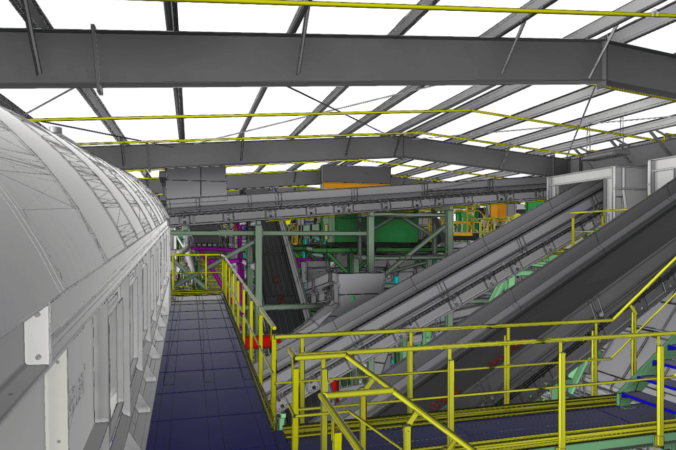
OAR captures complete site geometry using terrestrial laser scanning and delivers point clouds, Revit models, Civil 3D surface models, and as-built 2D CAD drawings at LOD 200-400. Your team designs from verified conditions, not assumptions. One mobilization. Complete data.
BIM Coordination & Virtual Construction
Multi-discipline coordination without building an internal team.
OAR runs clash detection across architectural, structural, civil, and MEP systems and manages the full coordination workflow. Your firm delivers coordinated, clash-free designs without maintaining in-house VDC staff or Navisworks licenses.
Digital Delivery & Implementation
Build the capability. Own the infrastructure.
For firms transitioning from 2D to BIM or building digital delivery capability and advanced services or offereings f, OAR provides BIM Execution Plans, Common Data Environment configuration, multi-source data integration, team training, and AI-ready data architecture. You get the systems and knowledge to sustain digital delivery after the engagement ends.
Project types we work on.
Complete facility documentation for renovation design: structural elements, MEP systems, site features, and spatial constraints captured in one mobilization.
Site surveys, topographic capture, and Civil 3D surface models for infrastructure design, grading, drainage, and utility coordination.
Verified facility documentation for environmental engineering projects: equipment locations, utility routing, and structural conditions for sites undergoing assessment, remediation, or repurposing.
As-built documentation and Integrated Project Twin development for waterfront infrastructure, dry docks, and marine facilities with complex multi-discipline coordination requirements.
Unifying laser scan data, geotechnical investigations, environmental sampling, aerial LiDAR, and design models into one coordinated BIM environment with shared coordinate systems.
2D-to-BIM transition consulting, CDE configuration, BIM Execution Plans, and team training for engineering firms building digital delivery capability for the first time.
Design-ready data in your format, on your timeline.
Survey-grade point cloud data at plus or minus 2 to 6mm accuracy. Formats: .E57, .RCP, .RCS, .LAS, .PTS. Compatible with Revit, Civil 3D, MicroStation, Navisworks, and AutoCAD.
Intelligent Revit models with parametric components: architectural, structural, and MEP systems at the level of detail your project requires. Dimensional accuracy verified against the point cloud before delivery.
Site topography, utility infrastructure, grading geometry, and alignment data for civil infrastructure design. Built from scan data for verified accuracy.
Plans, elevations, and sections extracted from 3D models. Delivered in .DWG format for teams that need 2D documentation alongside 3D.
Coordinated BIM environments combining laser scan data, geotechnical investigations, environmental sampling, and design models into a single navigable 3D environment.
Custom BEPs aligned with ISO 19650 and BIMForum standards. Common Data Environment configuration across Autodesk Construction Cloud, BIM 360, BoreDM, and ArcGIS.
BIM implementation for a national engineering firm.
Engineering Firm BIM Transformation First Large-Scale BIM Delivery
Alabama · Shipyard Expansion · Engineering Firm Waterfront Division
Hours logged across five projects
Large-scale project fully delivered in BIM for the client firm
Digital Delivery Maturity transformation initiated
A national engineering firm’s Waterfront Division needed to transition from traditional 2D CAD workflows to a full BIM environment for a major shipyard expansion. They had no prior large-scale BIM project experience. OAR provided consultation, training, and ongoing implementation support. The project became the firm’s first large-scale delivery fully executed in BIM, and served as the proof of concept for a firm-wide Digital Delivery Maturity transformation.
From the field.
“OAR’s team has been great to work with throughout multiple large-scale scan to BIM projects. High attention to detail, accurate scan data, proper BIM implementation and consistent communication and support from OAR has helped to improve our project quality and efficiency from start to finish.”
“Professional, timely and highly accurate scanning and modeling by OAR has saved me $$$. Having a single 3D source of truth for engineers, OEMs and tradesmen made my last project a breeze.”
“Our collaboration with OAR on the Mint gaming job has been exceptional. The team’s dedication and support have significantly improved the project’s progress, making my role as a Project Manager more enjoyable. I can’t praise the OAR crew enough for their contributions.”
Frequently asked questions
Scan to BIM converts 3D laser scan point cloud data into intelligent Building Information Models in Revit, Civil 3D, or MicroStation. For engineering firms, this provides verified existing conditions for renovation, retrofit, and infrastructure design without relying on outdated 2D drawings.
Yes. OAR converts point cloud data into intelligent Revit and Civil 3D models with architectural, structural, MEP, and civil components at LOD 200-400. Dimensional accuracy is verified against the point cloud before delivery. Models are design-ready and integrate directly into your workflow.
OAR uses survey-grade terrestrial laser scanners that deliver plus or minus 2 to 6mm accuracy depending on site conditions. This exceeds typical engineering design tolerance requirements and is suitable for structural analysis, clash detection, and fabrication coordination.
Field scanning takes 1 to 3 days for most commercial or industrial sites. Point cloud processing takes 2 to 3 business days. Scan to BIM Revit models take 5 to 10 business days depending on LOD requirements and project scope. Expedited delivery is available for urgent projects.
Yes. OAR routinely scans occupied buildings, active facilities, and operating infrastructure. Laser scanning is non-intrusive and non-contact. We coordinate with facility managers and schedule around your operational requirements.
Yes. OAR provides BIM Execution Plan development, Common Data Environment configuration, multi-source data integration, team training, and AI-ready data architecture. Our approach is practical: implementation on real projects, not abstract training. You build internal capabilities that last after the engagement ends.
Yes. AI-assisted design review, predictive scheduling, and automated quality analysis require unified data architecture: consistent formats, shared coordinate systems, and centralized access across disciplines. OAR builds that foundation through CDE configuration, data integration workflows, and standardized BIM practices. The organizations investing in data unification today will be the ones that can actually deploy AI when those tools mature.
Tell us about your firm and what you are working on. We will figure out where we can make the biggest difference.