3D Laser Scanning Scan to BIM As-builts
Outdated drawings, missing dimensions, and field assumptions kill schedules and budgets. OAR’s 3D Laser Scanning service captures existing conditions as they truly are: precise, verified, and delivered in whatever format your team needs to make confident decisions.
OAR provides 3D Laser Scanning, Scan to BIM, and as-built documentation for construction, industrial facilities, and infrastructure projects. Based in Portsmouth, New Hampshire, we serve the Northeast: Massachusetts, Maine, Vermont, New York, Connecticut, and Rhode Island. We also support projects nationwide for BIM and digital delivery work.
“Professional, timely and highly accurate scanning and modeling by OAR has saved me $$$. Having a single 3D source of truth for engineers, OEMs and tradesmen made my last project a breeze.”
What is 3D Laser Scanning?
3D laser scanning captures millions of precise measurements of existing buildings, facilities, or infrastructure using LiDAR technology. The output is a point cloud: a dense, spatially accurate 3D dataset that can be measured, navigated, and converted into Revit models or CAD drawings for design coordination, fabrication, and facility management.
Scan to BIM converts point cloud data into intelligent Building Information Models. OAR develops Revit models at LOD 100-350, modeling architectural, structural, MEP, and fire protection systems from laser scan data. The result is a construction-ready model for coordination, renovation, and retrofit projects.
Our laser scanners emit rapid pulses that measure distances to surfaces, capturing spatial data at millions of points per second. The result is a high-density point cloud with millimeter-level accuracy, providing a complete 3D record of existing conditions, far more accurate and comprehensive than traditional surveying methods.
You need 3D Laser Scanning when...
The building has been modified, expanded, or neglected since the last as-builts were drawn. You are designing against assumptions. We capture what is actually there so your team can design and coordinate from verified reality.
Your architects, engineers, or designers need accurate 3D documentation before they can start, especially in retrofit, renovation, or expansion projects. We deliver point clouds and models in the format your team uses.
Steel, mechanical, or specialty components need to be shop-fabricated to precise field dimensions. Guessing means rework. Our Scan to BIM models give fabricators the verified geometry they need before a single piece is cut.
Building owners, facility managers, or insurers need accurate records of what is built, not what was designed twenty years ago. We deliver as-built documentation in the format your operations team can use.
When designers, contractors, and owners all need to see the same building, a shared point cloud or model eliminates conflicting interpretations. We host your data in Cintoo Cloud or Autodesk Construction Cloud so every stakeholder has access.
In industrial facilities, MRFs, or power plants where HVAC, electrical, plumbing, and fire protection must all fit within tight spaces, laser scanning provides the verified baseline for 3D MEP coordination and clash detection.
From field conditions to usable data. In your format, on your timeline.
OAR delivers 3D Laser Scanning data in multiple formats, from raw point clouds to construction-ready Revit models. Choose the deliverable that matches your project workflow.
3D Point Clouds
The raw truth of your facility.
3D Point Clouds
- High-density, full-color LiDAR scan data
- Navigable, measurable, and shareable across your project team
- Formats: .RCP,. RCS,. E57,. LAS,. PTS
- Compatible with Revit, Navisworks, AutoCAD, and most BIM platforms
Best for: Any project needing verified existing conditions. The starting point for Scan to BIM, coordination, and fabrication.
Scan to BIM Revit Models
Construction-ready models built from scan data.
Scan to BIM Revit Models
- LOD 100-350 Revit models: architectural, structural, MEP, fire protection
- Built from point cloud data, not design intent
- Ready for BIM coordination and clash detection workflows
- Format: RVT (native Revit)
Best for: Retrofit and renovation projects. Coordination programs requiring verified existing conditions. Fabrication-ready shop drawing production.
As-Built CAD Drawings
2D documentation from 3D scan data.
As-Built CAD Drawings
- Plans, sections, elevations, and details extracted from scan data or Revit models
- For teams that need 2D documentation alongside 3D
- Format: .DWG (AutoCAD)
Best for: Design teams working in 2D. Permit sets. Facility documentation and compliance records.
Point Cloud Meshes
Lightweight 3D surface models for visualization.
Point Cloud Meshes
- Smaller file sizes than raw point clouds
- Accessible to non-technical stakeholders
- Formats: .OBJ, .FBX
Best for: Client presentations, planning reviews, and stakeholder walkthroughs where full point cloud access is not required.
Hosted Point Cloud Environments
Your data, accessible to anyone on the project.
Hosted Point Cloud Environments
- Hosted in Cintoo Cloud, Autodesk Construction Cloud, or your preferred environment
- Any stakeholder can access, measure, and annotate without specialized software
- No file transfers, no version control issues
Best for: Multi-team programs, remote design coordination, and facilities where ongoing access to scan data is needed post-delivery.
Field to deliverable. No black box.
Understand the purpose
Before we bring equipment on site, we need to know what you are going to do with the data. A scan for shop fabrication is scoped differently than a scan for facility documentation. We start by understanding your project goals, accuracy requirements, and downstream workflow.
Plan and mobilize
We plan field logistics including access, safety, scan coverage, and schedule, then deploy the right equipment. LiDAR, SLAM, photogrammetry, or a combination. We verify coverage and calibration on-site before we leave.
Process and build
Raw scan data is registered, cleaned, and QA checked. Then we build your deliverables: Revit models, CAD drawings, meshes, hosted environments. Every model is checked against the source data before delivery.
Deliver and stay available
We review deliverables with you, make revisions, and hand off finals in your preferred format and platform. If your project evolves and you need updates, additional views, or coordination support, we are already fluent in your facility.
3D Laser Scanning in the field.
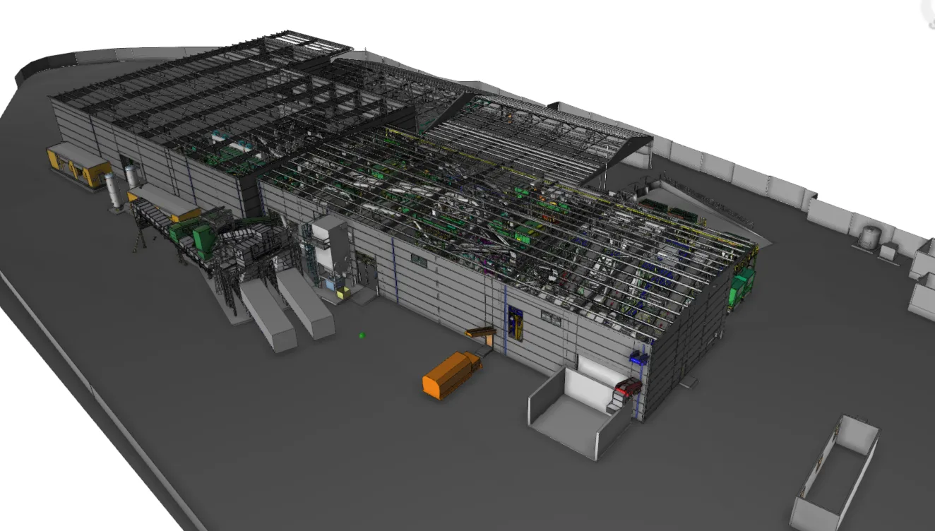
Large-Scale MRF Scan to BIM
Kansas City · Waste Management · Active Recycling Facility
Facility scanned
Revit model delivered
Return site visits required
An 86,500 SF active recycling facility with no reliable documentation of existing conditions. Dense equipment layout, significant electrical systems, and tight site conditions. OAR delivered a LOD 300 Revit model and registered point cloud, giving the design team verified existing conditions and remote access to measurements for VDC coordination and as-built documentation, without requiring repeated site visits.
From the field
“OAR’s team has been great to work with throughout multiple large-scale scan to BIM projects. High attention to detail, accurate scan data, proper BIM implementation and consistent communication and support from OAR has helped to improve our project quality and efficiency from start to finish.”
“Professional, timely and highly accurate scanning and modeling by OAR has saved me $$$. Having a single 3D source of truth for engineers, OEMs and tradesmen made my last project a breeze.”
“OAR attacks their projects methodically and professionally asking detailed questions regarding our final needs to fabricate. End result was a spectacular fit of formed powder coated aluminum angle under our cable guardrail system. Can’t wait to work with OAR on the next project!”
“Our collaboration with OAR on the Mint gaming job has been exceptional. The team’s dedication and support have significantly improved the project’s progress, making my role as a Project Manager more enjoyable. I can’t praise the OAR crew enough for their contributions.”
Frequently asked questions
Our laser scanners capture measurements with accuracy of plus or minus 3 to 5mm depending on equipment and range. Point cloud registration accuracy is verified against control points before processing. For most construction and industrial applications, this level of precision eliminates field conflicts and fabrication errors.
Field scanning typically takes 1 to 3 days depending on facility size and complexity. Point cloud processing takes 3 to 5 business days. Scan to BIM Revit models take 2 to 4 weeks depending on LOD requirements and project scope.
A point cloud is raw scan data: millions of measured points showing what exists. A Revit model is a 3D model built from that scan data, with parametric building components that can be coordinated, quantified, and used for construction and operations. Point clouds are best for visualization and measurements. Revit models are required for BIM coordination and fabrication.
OAR uses professional-grade LiDAR scanners (Leica, Faro, Trimble) for high-accuracy building interiors, SLAM-based systems for rapid capture in complex environments, and drone-based photogrammetry for large outdoor sites. Equipment selection depends on project accuracy requirements, site conditions, and timeline.
Point clouds: .RCP, .RCS, .E57, .LAS, .PTS. Revit models: .RVT. CAD drawings: .DWG. Meshes: .OBJ, .FBX. Hosted environments: Cintoo Cloud, Autodesk Construction Cloud.
We scan both. Interior spaces use tripod-based LiDAR for maximum accuracy. Exterior sites use SLAM systems or drone-based systems depending on size and terrain. We have captured everything from cramped mechanical rooms to multi-acre industrial facilities.
Yes. OAR delivers as-built point clouds, 3D Revit models, and 2D plans, sections, and elevation views in the format your project requires.
Cost depends on facility size, complexity, access constraints, and deliverable requirements. Send us a message with your project details and we will put together an accurate proposal.
General Contractors & Construction Managers: verified existing conditions before design, fabrication, or retrofit. Eliminates field surprises and protects your schedule.
MEP Subcontractors: scan data as the foundation for fabrication and coordination. Your assemblies fit because the geometry was verified before shop drawings were produced.
Owners & Facility Managers: accurate as-built documentation for operations, compliance, and future capital planning. One source of truth that stays useful after the project closes.
Engineering & Environmental Firms: existing conditions documentation to support design, analysis, and reporting without repeated site visits.
Service areas
Field work in the Northeast. BIM and digital delivery anywhere.
3D Laser Scanning │ Scan to BIM │ As-builts
Connecticut · Massachusetts · Maine · New Hampshire · New York · Rhode Island · Vermont
We mobilize across the Northeast for site capture, existing conditions, and as-built documentation. We work in occupied facilities, active industrial sites, and tight shutdown windows. Scan-to-delivery in 2 to 3 weeks.
Working on a project outside the Northeast? Let’s talk. We are always open to figuring out how to make coverage work when the project calls for it.
BIM Coordination & Virtual Construction │ Digital Delivery & Implementation
Remote and on-site across the US
Both services are delivered remotely for most engagements, with no mobilization cost. BIM Coordination & Virtual Construction has no geographic constraint on clash detection, MEP coordination, or managed VDC. Digital Delivery & Implementation onboarding is fast. Most engagements start within a week of scope alignment.
For most of our clients, laser scanning is where the project starts, not where it ends.
Once we have captured your facility, our BIM Coordination & Virtual Construction team can resolve conflicts in 3D before your crew arrives on site. And if you are building a long-term scanning and BIM capability, our Digital Delivery & Implementation team can design the systems and training to make it repeatable.
Professional-grade laser scanning technology.
LiDAR Scanners
Leica RTC360, Faro Focus, Trimble TX series for high-accuracy building capture (plus or minus 3 to 5mm accuracy)
SLAM Systems
GeoSLAM, NavVis for rapid capture in complex or confined environments
Photogrammetry
Drone-based capture for large outdoor sites and infrastructure
Processing Software
Autodesk ReCap, Leica Cyclone, Faro Scene for point cloud processing
BIM Platforms
Autodesk Revit, AutoCAD, Navisworks, BIM 360, Autodesk Construction Cloud
Hosted Environments
Cintoo Cloud, Autodesk Platform Services for web-based point cloud access
Tell us about your facility or jobsite. We will scope a scanning plan that fits your project and timeline.